This article was featured in One Great Story, New York’s reading recommendation newsletter. Sign up here to get it nightly.
Klaus Jacob, a German professor affiliated with Columbia’s University’s Lamont-Doherty Earth Observatory, is a geophysicist by profession and a doomsayer by disposition. I’ve gotten to know him over the past few years, as I’ve sought to understand the greatest threat to life in New York as we know it. Jacob has a white beard and a ponderous accent: Imagine if Werner Herzog happened to be a renowned expert on disaster risk. Jacob believes most people live in an irrational state of “risk denial,” and he takes delight in dispelling their blissful ignorance. “If you want to survive an earthquake, don’t buy a brownstone,” he once cautioned me, citing the catastrophic potential of a long-dormant fault line that runs under the city. When Mayor Bloomberg announced nine years ago an initiative to plant a million trees, Jacob thought, That’s nice — but what about tornadoes?
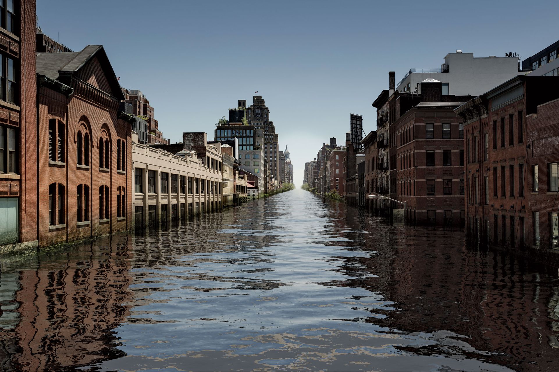
For the past 15 years or so, Jacob has been primarily preoccupied with a more existential danger: the rising sea. The latest scientific findings suggest that a child born today in this island metropolis may live to see the waters around it swell by six feet, as the previously hypothetical consequences of global warming take on an escalating — and unstoppable — force. “I have made it my mission,” Jacob says, “to think long term.” The life span of a city is measured in centuries, and New York, which is approaching its fifth, probably doesn’t have another five to go, at least in any presently recognizable form. Instead, Jacob has said, the city will become a “gradual Atlantis.”
The deluge will begin slowly, and irregularly, and so it will confound human perceptions of change. Areas that never had flash floods will start to experience them, in part because global warming will also increase precipitation. High tides will spill over old bulkheads when there is a full moon. People will start carrying galoshes to work. All the commercial skyscrapers, housing, cultural institutions that currently sit near the waterline will be forced to contend with routine inundation. And cataclysmic floods will become more common, because, to put it simply, if the baseline water level is higher, every storm surge will be that much stronger. Now, a surge of six feet has a one percent chance of happening each year — it’s what climatologists call a “100 year” storm. By 2050, if sea-level rise happens as rapidly as many scientists think it will, today’s hundred-year floods will become five times more likely, making mass destruction a once-a-generation occurrence. Like a stumbling boxer, the city will try to keep its guard up, but the sea will only gain strength.
No New Yorker, of course, needs to be reminded of the ocean’s fearsome power — not since Hurricane Sandy. But Jacob began trying to sound the alarm about the risk more than a decade ago. He sent students into the New York subways with barometers to measure their elevation, and produced a 2008 report for the MTA, warning that many lines would flood with a storm surge of between seven and 13 feet. He urged policymakers to “muster the courage to think the almost unthinkable” and install flood defenses while considering whether, over the long term, climate change might necessitate radical alterations to the transit system, like moving back to elevated tracks. In 2011, while working on a government panel, Jacob produced a study that mapped how subway tunnels would be inundated in the event of a hurricane. The next year, he was proved right. After Sandy, Jacob was hailed as a prophet.
“Nature cooperated — at first timidly, with Irene, and then a little bit more forcefully with Sandy. And God forbid what’s next,” Jacob told me. “One way or another, we get educated, and it’s much cheaper to listen once in a while to engineers and scientists.” Yet Jacob’s moment of vindication was accompanied by an ironic comeuppance: He had been flooded too. A few weeks after the storm, I paid a visit to the professor’s home in the village of Piermont, on the Hudson River just north of the city. The ground floor of his quaint clapboard house was a jumble of furniture, and he pointed to a pen mark two feet up the wall — the height the water had reached. Many of those who lived around him fared worse; there were huge piles of debris up and down his street. Outside, Jacob noticed a neighbor hanging up some early holiday decorations. “I like your spirit,” he shouted. “Put a little light into the misery!”
Jacob’s personal disaster illustrated, in microcosm, how difficult it can be for anyone, even scientists, to pay heed to science. Despite his acute awareness of risk, he had chosen to make his home on a lane that bordered a grassy marsh. Sitting in his third-floor office, with classical music playing softly in the background, Jacob recounted how he had purchased the house after his wife, an artist, fell in love with it. “When I saw it, I said, ‘Oh, God, I can’t do this, this is against all my professional ethos,’ ” Jacob said. “There are other considerations in life that enter into these decisions. I tried to convince her as a scientist, but I’m married to her.” Jacob had taken some protective steps, raising the house’s foundation two feet above the FEMA flood line, and hoped for the best.
Every year, summer through fall, Jacob would closely monitor reports from the National Hurricane Center, and he followed Sandy online as it blew in from the Caribbean. “I saw the storm moving up the coast,” he said. “This tide gauge, the next tide gauge.” When Sandy hit New York City, as a mammoth cyclone more than a thousand miles in diameter, a wall of water rushed over Staten Island and the Rockaways and up through the Narrows. Jacob took a look at the readings from Battery Park, showing an unprecedented 14-foot storm surge, and resigned himself to the inevitable. An hour later, the surge reached his house. “My wife was sitting on the stairs, watching the water coming under the door and up through the floorboards,” Jacob said. “I was sleeping, because I knew within half a foot where the water would go.”
No one is very good at acting on the unthinkable. We now know, without scientific question, that the Earth is warming fast, that 2016 is on pace to be the hottest year in the books, setting a record for the third year in a row. We know that glaciers are melting. We know the water is coming. No serious thinker doubts this man-made reality any longer. Yet climate-change denial comes in subtler forms. Try as we might to contemplate how New York City might go under, our imagination fails us.
To begin to fathom what the future could hold for New York, I went to the Princeton office of a research organization called Climate Central, which has developed programs that map out sea-level projections. Climate scientist Ben Strauss set me up on the most advanced version, which uses 3-D Google Earth imagery, and apprised me of the latest gloomy research. Policymakers may trumpet the Paris Agreement, signed this year, which aims to cut carbon emissions enough to hold global warming to a target of 1.5 to 2 degrees Celsius above preindustrial temperatures, but even if the accord succeeds, some change is “locked in,” because we’ve already spewed so much carbon into the atmosphere. Strauss added that in Antarctica, enormous glaciers appear to be melting faster than previously estimated, making the current worst-case projections look more and more like probabilities. “It’s kind of unimaginable,” Strauss said. With his program, though, I could visualize it.
Using a special 3-D mouse, I swooped like a drone over a familiar reference point at the corner of Canal and Varick Streets: the landmarked former industrial building that houses this magazine’s offices. With one foot of sea-level rise, the map didn’t change that much. At three feet, though, a tide of blue covered Hudson River Park and West Street. Four feet, five feet: The blue crept east along Canal, toward the entrance to the Holland Tunnel. At six feet, my office building was almost an island. It has been standing for 86 years; six feet of sea-level rise could quite possibly occur before another 86 years pass. Looking elsewhere, the blue covered parts of La Guardia and JFK airports, the Williamsburg waterfront, Roosevelt Island, and Brooklyn Bridge Park.
Of course, the water won’t stop rising in 2100. Strauss told me that even the supposedly manageable increase of 1.5 degrees Celsius envisioned by the Paris Agreement would translate to around ten feet of eventual sea-level rise. When I clicked up to ten feet, much of Battery Park City, the Lower East Side, and Brooklyn’s waterfront was submerged. The Dumbo carousel stood solitary in the East River, and the barrier spits of the Rockaways and Coney Island mostly vanished. The program also has a function that allows you to see the outcomes of greater increases in temperature. At 2 degrees — equivalent, in Climate Central’s estimation, to about 15 feet in sea-level rise — the water completely surrounded the pools of the 9/11 memorial. At 3 degrees — 20 feet — the water overwhelmed them. I clicked up to the maximum setting of 4 degrees — 30 feet — and maneuvered upward to take in the view from the top of the spire of One World Trade Center. Lower Manhattan had become an archipelago, and the rooftops of southern Brooklyn resembled boats bobbing in a marina.
How likely are these outcomes? The latest scientific data suggests that we are already nearing the 1.5-degree-Celsius threshold, and the trend line is only headed in one direction. “A lot of people are now talking about 3 or 3.5 degrees Celsius,” said William Solecki, a Hunter College geography professor. “We have a challenge grappling with the implications.” The Port of New York has enjoyed centuries of prosperity, but it seems its geographic luck has run out. Few places on Earth are as vulnerable to sea-level rise. (Among other reasons, this is because the northeastern coast of the United States is simultaneously sinking, owing to the natural process of subsidence.) At the Battery, tidal readings are rising at twice the global rate.
“We can’t wrap our heads around the fact that the future could be different,” said Solecki, who co-chairs the New York City Panel on Climate Change, a consortium of experts that advises the city government. (Klaus Jacob works with the panel, too.) When I visited him at his office earlier this year, Solecki had been preparing to speak at a conference in the Netherlands on the subject of climate adaptation, alongside presenters from London, Lagos, and Kolkata. Coastal cities around the world have just begun to awake to the possibility that sea-level rise could force fundamental changes. “New York is not going to go away,” Solecki said. “But how will it change? How will this pressure be expressed?”
Among those who spend their days considering the implications of global warming, Solecki counts as an optimist. “A lot of the climate scientists, I wouldn’t say they’re depressed, but it’s a very complicated and challenging issue,” he said. For now, most policy is focused on “mitigation,” or changing energy-consumption patterns in the present day. That is already a daunting problem, so long-term adaptation gets less attention. In part, that is because it is hard to address it without sending the public a conflicting — and quite dampening — message: that ultimately, mitigation is futile.
“There’s this tendency for scientists to understate the threat,” says Naomi Oreskes, a Harvard professor who studies the history of science. “There are cultural pressures to be calm and not talk about the worst-case scenario.” Imaginative leaps are the stuff of disaster movies, and few are eager to be cast in the Jeff Goldblum role. But Oreskes argues that scientists shouldn’t be afraid to state the implications of their research. “The facts are alarming,” she says. “If you really think seriously about what this all means, it is very, very upsetting.”
Two years ago, Oreskes co-authored a novel titled The Collapse of Western Civilization: A View From the Future, which presented itself as a report, written in 2393, analyzing our contemporary inaction. On one page there was a map of New York, largely reduced to a rump portion of Midtown and Upper Manhattan and a central-highland swathe of Brooklyn and Queens. Oreskes says she looked at the science and tried to extrapolate the absolute worst that could happen, just as a thought experiment. “The really scary thing,” she adds, is that the latest scientific findings are making her fictional scenario look less and less extreme. “Guess what? Our numbers aren’t as exaggerated as we thought.”
In his public talks, Klaus Jacob likes to show a similar map, depicting what New York’s coastline might have looked like in the mid-Pliocene epoch, 3 million years ago, the last time the amount of carbon in the atmosphere was around today’s level of 400 parts per million. Sea levels were some 30 meters — or nearly 100 feet — higher. “I am a little bit of an oddball,” he admits, “because I’m saying, ‘Hey, now that we have those forecasts, guys, what are we doing about it?’ ” In panel discussions, he takes self-evident pleasure in playing the prickly contrarian, dismissing popular measures like building dunes or cultivating oyster beds to create natural buffer zones against storms. “Oyster beds are great if you are using them in your kitchen,” he said, sarcasm dripping, at a 2012 forum moderated by David Remnick of The New Yorker.
“In the long term, Klaus is right,” said another white-bearded panelist, Malcolm Bowman, an oceanographer and a longtime proponent of building massive storm-surge barriers to protect New York. “Maybe 200, 300 years from now, the city will no longer be.”
“Earlier!” Jacob interjected.
“However, in the meantime,” Bowman continued, “there’s a lot we can do to save the city, Klaus, before we have to run for the hills.”
At another event, held at NYU, moderator Chelsea Clinton made an earnest observation about “what is working,” mentioning sea gates and — once again — oysters. Jacob responded with a declaration that “our urban planning is irrelevant” and decried “shortsightedness of decision-making.” As an example, he cited the Hudson Yards development, just one of many waterfront megaprojects that the city has continued to enthusiastically promote, even after Sandy. He thinks that the government should instead rework its policies to relocate assets away from the water.
“We have this particular problem in New York,” another panelist said, “because the land that we would need to retreat from happens to be worth hundreds of billions of dollars.”
“Now,” Jacob retorted.

To behave as if the New York coastline is an immutable fact is to disregard not just science but history. Over a few centuries, humans have thoroughly remade the city’s topography, leveling hills, channeling streams, draining ponds, creating new landfill out of construction debris. When workers were excavating the foundation of the redeveloped World Trade Center, they discovered, buried deep beneath the ruins, the hull of an 18th-century shipwreck — an eerie reminder that even our tallest towers sit on land claimed from the water. Our ingenuity, and our real-estate speculation, have made the city a continually expanding entity. We are not used to contemplating contraction.
After Sandy, Mayor Bloomberg pledged to direct some $20 billion in disaster aid into “climate resiliency” measures, such as floodproofing buildings by moving mechanical equipment to upper floors. In areas that were hit hard by the storm, many homeowners have taken advantage of a city program called “Build It Back,” reconstructing their houses high up on stilts. Beneath this defiant civic agenda is an old, blithe assumption that New York is too rich, too important, too tough, to ever give up an inch of real estate. “We still have essentially the gung ho, Wild West way of doing business in this country, where we think we are the master of nature,” Jacob said. “Fighting, building barriers, instead of accommodating the ocean.”
If sea-level rise reaches 2.5 feet, the floodplain for a hundred-year storm will expand to nearly a quarter of the city. The climate-change panel predicts that could happen by 2050, which still leaves some time for long-range planning. That is the kind of foresight that used to be New York’s specialty: The Commissioners’ Plan of 1811, for instance, established the street grid that defines Manhattan above Houston to this day. At present, however, the city appears to be unable to accept the fact that it faces an inevitable reckoning. The human tide is moving in the wrong direction, still marching toward the waterline.
Over the last generation or so, New York’s grimy industrial waterfront has been a primary venue for the city’s renewal, becoming much more densely populated. Seedy warehouse districts have been redeveloped as luxury housing. Rotting docks have been remade into the magnificent Hudson River and Brooklyn Bridge parks. Name an important recent development project, and it’s probably within the climate-change panel’s projected floodplain for 2050: the World Trade Center, Hudson Yards, the Brooklyn Navy Yard, all the new luxury-apartment towers in Williamsburg and Long Island City, Cornell University’s new technology campus on Roosevelt Island, the new Whitney Museum, much of Mayor de Blasio’s proposed Brooklyn-to-Queens streetcar line.
The most clear-eyed analysis of the risk to such developments comes from the insurance industry, which has countless billions of dollars at stake. The firm Swiss Re predicts that as a consequence of climate change, the industry’s anticipated annual losses in New York will more than double by 2050, to $4.4 billion, and the cost of black-swan events that happen on average around once every 70 years will more than quadruple, to $90 billion. Already, the MTA has found itself practically unable to purchase flood insurance for the subway system. Instead, it has had to rely on an exotic debt instrument called a catastrophe bond, paying a relatively high interest rate to investors who are essentially making a short-term wager against the possibility of a disaster. The scale of the risk, though, defies any hedging. A recent national study by the real-estate firm Zillow found that six feet of sea-level rise would inundate some 2 million homes, with a cumulative current value of $882 billion. About half of the vulnerable properties are in Florida. But even the presence of water on the streets of Miami Beach during high tides is not enough to deter development. “There is this mismatch of time horizons,” says Robert Muir-Wood, the chief research officer of RMS, a firm that analyzes catastrophe risk for the insurance industry. An insurance policy typically lasts just one year; private investors think in terms of a 30-year mortgage — or less, if they can flip a building for a profit.
And so, billions in private and public money are being spent to develop more housing that will move more New Yorkers into places that may not withstand the next Sandy. The short-term incentives create situations like the one now happening around the polluted Gowanus Canal, where local bloggers recently posted pictures of high tides swelling disconcertingly close to a new 700-unit apartment complex offering two-bedroom rental units for $7,000 a month. If the buildings generate that kind of money for 30 years, maybe the owners don’t care if the complex doesn’t make it to 40.
There is an entity that is supposed to be invested in the fate of the city over its entire life span: the government. But in reality, it is most responsive to the immediate concerns of living voters, rather than the problems of the next century. “As New Yorkers, we cannot and will not abandon our waterfront,” Mayor Bloomberg declared after Sandy. Since then, he and his successor have walked a tricky line, preaching preparedness and revising codes to ensure that new buildings are more water-resistant, but rejecting any suggestion of curtailing development. Each mayor, in his own way, has seen waterfront land as a precious political resource. Recently, for instance, de Blasio proposed creating affordable housing, his highest priority, in rapidly gentrifying Gowanus. While the mayor recognizes sea-level rise as a real threat, the problem of rising rents feels more urgent.
Even more troubling than buildings, though, is the question of the infrastructure: what to do about all the power plants, fuel terminals, highways, subway stations, and sewage-treatment facilities that already sit in the floodplain and can’t easily be relocated. Both of the city’s airports are close to sea level, and La Guardia airport was deep underwater during Sandy. Muir-Wood predicts that globally, “high tide” might soon be added to the list of reasons for routine flight delays. But at least the runways are aboveground — tunnels are even harder to address. On a dry day, the MTA already pumps 13 million gallons of groundwater out of the subway system. It is trying to seal hundreds of “points of egress,” busily installing floodgates on subway entrances throughout lower Manhattan.
Daniel Zarrilli, who runs the Mayor’s Office of Recovery and Resiliency, told me the city is pressing a program of retrofits and building-code revisions designed with extra buffering to anticipate seas that are around two feet higher — the 2050 benchmark. He anticipates future administrations will build on that. Nonetheless, he added: “The major focus for us is reducing vulnerability now.”
The government is planning or constructing seawalls and other defenses to protect numerous strategic points around the city, including La Guardia and Hunts Point Market — the hub of the city’s food-distribution network, which only narrowly averted being disabled by Sandy. But New York City has 520 miles of coastline, and the government can’t build a wall around it all. Sweeping infrastructural solutions, like Bowman’s proposal to build a retractable storm-surge barrier across the mouth of New York Bay, have garnered little political support. “It creates the perception that there is one big thing we can do and we’ll all be safe,” said Zarrilli, who added that the project would cost $25 billion and have “zero impact on sea-level rise.” The storm-surge barrier would remain open during normal weather, to allow the rivers to discharge into the sea, so while it might deflect another hurricane, it wouldn’t save the city from the melting ice caps.
Instead of investing in that one big thing, then, the city is distributing its billions toward many more modestly scaled defenses. Most visibly, it will soon start construction on a berm system and park, primarily designed by architect Bjarke Ingels, which will shield 2.4 miles of Manhattan along the East River, including a crucial power station. Zarrilli says the middle of this century is the limit of the city’s current planning horizon and is dismissive of naysayers like Jacob who argue that current policies only shift the burden to future generations.
“I’ve seen Klaus’s maps showing what 30 meters of sea-level rise would mean for New York City,” Zarrilli says. “I think that is exactly the wrong way to provoke action. That paralyzes you. Focusing on the here and now, the natural time frame ahead of us that we can work within, that’s how we’re going to move the needle.”

For the next few decades, the time period Zarrilli is talking about, the problem should remain merely expensive. It’s during the second half of the century that it will start to become unmanageable. And after 2100, the numbers get really ugly. The New York City Panel on Climate Change has not yet extended its sea-level modeling into the next century, but a similar commission in Boston recently projected a 20-to-30-foot increase by 2200 if emissions continue at a high rate. That is why Jacob says it was “almost irresponsible” for Zarrilli to describe him as alarmist. “We should go into it with open eyes and look at the possible realities,” he says. “Anything less than that is pretty scary.”
Jacob says he is disheartened by the government’s near-term fixation, and he has been trying to take his message to more-receptive audiences, like architects. “Scientists only make the predictions; they don’t do the adaptation,” he says. “These are the people that need to get in the game, because it’s an urban-planning and urban-design issue.”
In March, Jacob gave a speech to the New York chapter of the American Institute of Architects, seeking to warn the audience about the danger of poor development decisions. He displayed renderings of a proposed Red Hook project and showed how it could be accessible only by ferry in 2100, and ridiculed the World Trade Center redevelopment. “You can ask yourself all sorts of questions, whether or not that will make it,” he said, and displayed a diagram of how a hundred-year storm would flow into Santiago Calatrava’s new $4 billion transit hub. “If you look at this, where is the water going? It’s not nice.” He said that the protective park Ingels has designed might be effective for the rest of the century. “The problem I foresee,” he warned, “is that we might start to feel very happily safe behind that.” Jacob told his audience that the city should instead be planning to accommodate the water. “Make Water Street a water street,” he said, “and Canal Street a canal street.”
Many architects are thinking along similar lines, as they try to envision how structures built today might be designed to accommodate rising sea levels over their lifetimes. In his talk, Jacob singled out SHoP’s plan for the Domino Sugar Refinery project on the Brooklyn waterfront, which he said would survive even if the East River goes 30 feet higher. Other architects are designing floating neighborhoods, or apartment buildings that are suspended from bridge structures, rather than supported by foundations. There’s a lot of excitement around the idea of leaving the ground level empty, as a floodable public space. (So long to storefront retail, and those quaint nostrums about “street life.”) Some of these approaches are already being tested out in European cities like Hamburg and Amsterdam.
“Maybe we can imagine New York City becoming something like a 22nd-century Venice,” says Catherine Seavitt, a landscape architect. Almost a decade ago, she and her husband, structural engineer Guy Nordenson, collaborated with others on a conceptual plan to remake New York Harbor with artificial islands, wetlands, and underwater reefs made of retired subway cars. The project inspired a 2010 exhibition at the Museum of Modern Art called “Rising Currents.” Afterward, they began to apply their design principles in real life, working on a Rockefeller Foundation–funded project called Structures of Coastal Resilience. In New York, the initiative’s primary focus is on Jamaica Bay and the Rockaway Peninsula.
“It’s an interesting place for a pilot project,” Seavitt said, telling me that the guiding idea was “not necessarily a retreat scenario, but much more amphibious.”
To show me what she meant, Seavitt invited me to meet her one scorching summer day on Jamaica Bay’s only inhabited island. In Broad Channel, a blue-collar neighborhood of around 2,400 people, many houses back onto watery slips, about as wide as a city street, where homeowners keep watercraft docked. Like the other areas of the city that are most exposed to the sea, Broad Channel was hit hard by Sandy. Whatever wave is headed for the city will crash there first. Still, the residents of Broad Channel aren’t ready to give the place up. Some have used the Build It Back program to raise their houses. City paving contractors are working to elevate the streets, which are currently so close to sea level that they sometimes flood at high tide.
Don Riepe, a naturalist who lives in Broad Channel, took us out for a tour on his 22-foot motorboat. “We have to start thinking about where we can be more porous,” Seavitt said as Riepe piloted the boat into recently restored marshes, which offer the bay some protection during storms while also serving as a habitat for egrets, ospreys, and other wildlife. The federal government, though, has proposed to construct more muscular protections. Riepe pointed to a spot beyond Ruffle Bar, a bird sanctuary, where the Army Corps of Engineers is considering a plan to build a retractable storm-surge barrier.
If constructed, the barrier would be the linchpin of a $3.8 billion network of seawalls, dunes, and other infrastructure that will potentially stretch from Coney Island out to the eastern end of the Rockaways. The planned defenses wrap around Breezy Point, the Queens enclave that was pummeled by Sandy, but they aren’t just meant to protect people. Riepe steered the boat toward John F. Kennedy airport, passing beneath an A train as it rumbled over the rail bridge toward the Rockaways. It was high tide, and he was able to navigate disconcertingly close to the runways.
Like Jacob, though, Seavitt was skeptical about the plans for fortification. “I think the big fix is a false narrative,” she said. An irregularly used storm-surge barrier wouldn’t do much to help Broad Channel survive. Riepe is already used to having water wash across the ground floor of his house. “Nuisance flooding,” he said, “you just have to live with that.”
Soon enough, in places like Broad Channel, the nuisance will become overwhelming. “All of those areas, they’re all gone,” predicts Illya Azaroff, an architect who has been a leader in public initiatives to contend with climate change. “Underwater by maybe just a foot to two feet at that point, but uninhabitable with the type of buildings we have now. And even if we did adapt the building stock, as we are doing now by just elevating, that does not address the 2100 issue.” By then, the most serious problem will involve “the infrastructure that makes a building run: electricity, potable water, all the services that come to it,” he says. “They aren’t being addressed in any planning that we’ve seen.”
Much of that infrastructure will probably have to be relocated eventually — somewhere, somehow. That is why Jacob argues that New York should be preparing for a “managed retreat.” Right now, it’s a fringe position, an option of last resort in places like the Netherlands, where a program called “Room for the River” is employing eminent domain to move dikes inland, and the bayous of Louisiana, where the U.S. government is spending $48 million to relocate the population of an island. But Jacob says we will have to get used to the idea of giving in to nature. After Hurricane Katrina, he wrote a column in the Washington Post arguing against rebuilding. (“There is no way — no way — you can save New Orleans,” he told me.) He brushes off practical counterarguments about sunk costs and current property values, as well as political impossibilities, saying he operates by a “Kantian imperative.”
Jacob told me that if I wanted to see what a future of managed retreat might look like, I should visit a neighborhood on the south shore of Staten Island. Oakwood Beach, a community of small wooden bungalows, experienced the city’s highest levels of inundation during Sandy. Afterward, its residents formed a committee to petition the state government for buyouts. “They didn’t need to see the statistics,” Joe Tirone, the property owner who led the effort, said one June day as he drove around the remnants of the neighborhood. “No scientists had to come and prove it to them. They were living it.”
Though a few holdouts remain, most of the houses in Oakwood Beach have been demolished, leaving behind empty puddled streets and tall phragmites waving in the sea breeze. Walking around on foot, Tirone and Liz Koslov, a Ph.D. candidate at NYU who has closely studied the retreat process, struggled to mentally reconstruct which houses stood on which vacant lots. “It’s weird that things are disappearing,” Koslov said. “You lose your bearings.” We followed a path out to a beach littered with tires and bottles, where some locals were driving a dune buggy. Sandy Hook was across the bay to the right, the Parachute Jump and Coney Island to the left, open ocean straight ahead.
“This funnel effect just kind of converged here” during Sandy, Tirone recalled. “Our wave was about 15 feet.” When we returned to the street, Tirone pointed out a makeshift cross standing in one of the lots, where a father and son had drowned. “The people who died were down in their basement, trying to fix their sump pumps.” Survivors rode out the storm on their roofs. After going through that, most residents were happy to take the state’s offer to pay the pre-disaster value of their homes. All told, the buyout program has bought more than 450 houses in Oakwood Beach and two neighboring communities, at a cost of nearly $190 million.
The program did not turn out to provide a model for the rest of the city, though, for reasons that were both economic — land elsewhere in New York is more expensive — and anthropological. Just next door, the vast majority of residents of Midland Beach stubbornly rejected retreat, choosing to rebuild behind an $580 million seawall the Army Corps is planning. Tirone, a real-estate broker by profession, told me he recently represented some investors at a government auction of storm-damaged houses. “There is an insatiable demand for those properties,” he said. “It’s like it’s never going to rain again.”
The water will rise, though. “The question is when,” says Columbia University climate scientist Vivien Gornitz, who has worked on the New York City Panel on Climate Change’s projections. “How fast, how soon? And I don’t think anybody knows.”
The answer is buried in the Earth’s glaciers, which warehouse enough water to increase sea levels by some 230 feet. In her 2013 book Rising Seas, Gornitz writes that although the glaciers have been stable for the last 6,000 or so years, they have fluctuated in the geologic past, freezing and then thawing in “pulses.” The last time the climate was this hot, around 100,000 years ago, the oceans were between 13 and 30 feet higher than they are today. It’s reasonable to assume, therefore, that we’ve already locked in that amount of sea-level rise; with a few more degrees of warming, we could be looking at truly biblical scenarios. Just as a handful of ice cubes won’t disappear as soon as you drop them in a glass of tap water, the glaciers won’t collapse once the temperature hits a certain threshold. But sooner or later, the cubes will melt.
In the geologic past, glacial retreats happened over the course of thousands of years, and if that is how the ice melts this time, cataclysmic sea-level rise is some other civilization’s problem. There is ample reason to believe, however, that “human forcings” — the technical term for all the pressure our insatiable demand for energy puts on the environment — will make this meltdown different. A paper published earlier this year in the journal Nature found that the massive West Antarctic Ice Sheet could soon collapse, by itself adding three feet to sea levels by 2100, and a foot per decade after that. “Then the 22nd century,” Ben Strauss says, “becomes one of constant upheaval, retreat, and adjustment.” But a group led by James Hansen, a retired NASA climate scientist, published their own paper this year, advancing the controversial theory that an oceanic chain reaction could cause the ice sheets to melt even sooner, causing “several meters” of sea rise, storms like no human has ever witnessed, and the loss “of all coastal cities.” In a recent email, Hanson wrote me: “Will the full-fledged consequences be in 50 years, 100 years, 150 years? I can’t imagine it will be greater than that range.”
Somewhere between Hansen’s timeline and the geologic one, you can start to conceive of the end of New York. The human capacity for adaptation has its limits, and while Jacob says the Domino complex is a model of farsighted architecture, will anyone want to live in a luxury apartment on Kent Avenue when it regularly turns into a river? We can keep building seawalls, but they will need continual reinforcement to remain effective against intensified storms, and history would suggest that we cannot count on political institutions to make such investments. (The tendency to procrastinate is one constant in the sea-level equation.) Maybe after a future hurricane, the city government will turn all the lovely waterfront parks we’ve recently built into 50-foot berms. Or maybe it will decide to accept a new relationship with water — the gondola option. Probably the most likely outcome, though, is an inconsistent response, leading to a new form of elevation-based inequality. The core of Manhattan will become a walled city of privilege. Everywhere else will have to absorb the runoff.
Some of the most interesting speculation about the implications of sea-level rise is happening in the realm of science fiction. In his forthcoming New York 2140, science-fiction novelist Kim Stanley Robinson draws on Hansen’s research and imagines a version of Manhattan after a pair of glacier pulses have raised sea levels 50 feet, breaching “Bjarke’s Wall” in a great disaster that floods Manhattan up to around the Empire State Building. But in many ways, New York persists. His characters live in the Metropolitan Life tower at 23rd Street, drive boats to their office jobs, bitch about traffic on the East River, and profit off gentrification in the intertidal area of midtown, “a zone of squatters and scammers and street people out to have some fun.” Robinson told me he was interested in writing a book that demonstrated that it “is not necessarily the case that a catastrophe like that would end capitalism.”
To anyone who went through Sandy, Robinson’s presumption carries a ring of truth. I rode out the storm in a second-story apartment in Gowanus, right on the edge of the evacuation zone, watching warily as inky-black canal water inched over the fuel-oil depot down the street. It felt like the end of the world, but soon enough, the city dried out and went back about its business. One day soon afterward, Jacob met me in my neighborhood. We walked down 9th Street — which routinely floods already when it rains — and looked down from a drawbridge at the Gowanus Canal. Once a tidal creek, it is now a Superfund site, a designation that (amazingly) hasn’t scared off property investors.
“If you think about the long term, this will be phragmites and marshland,” Jacob said. “What was the Gowanus marsh will sooner or later become the Gowanus marsh again.” When I later looked at the Climate Central maps, I saw that ten feet of water would completely submerge the area. But nearby, I noticed a patch of leafy, undeveloped land, which stayed dry in even the most apocalyptic scenario: Green-Wood Cemetery. Jacob likes to morbidly observe that some of the highest ground in New York — and some of its most desirable future real estate, perhaps — is currently occupied by graveyards.
“I think we should switch the living and the dead,” he had told an incredulous audience at a forum a few days before. “We laugh, but I think the dead would agree with us.”
You won’t live to see the flood. But it still may move your bones.


